

What if you could see your city through the eyes of its residents? Pinpoint exactly what works, what doesn't, and what's truly desired—from all different perspectives? Welcome to the power of community mapping, an essential tool for planning lovable, livable communities
This guide is a deep-dive into community mapping, including essential methods, tools, steps, and examples to help urban planners move away from scattered public comments towards inclusive, community-driven planning.
Understanding Community Mapping: Definitions, Principles, and Purpose
What is community mapping?
Community mapping is a community engagement method where people share their insights directly onto a map, often as an early step in a planning or development process. This grassroots understanding, rooted in local lived experiences, informs responsive and equitable urban planning, policymaking, and community development.
While seen in a variety of contexts, community mapping is an especially impactful application in urban planning and development, particularly at the local and neighborhood scales. Depending on the project or plan, the involved community can range from the broader public to specific demographic segments (e.g., students, local businesses, or select stakeholder groups).
Often initiated early in the planning process, community mapping helps planners gather rich, localized data and conduct comprehensive community needs assessments. Using paper maps or digital mapping platforms, participants are invited to identify and evaluate their local barriers, resources, and assets. In fact, terms like "asset mapping" and "resource mapping" often describe similar processes, but "community mapping" typically emphasizes a broader, more active, and inclusive process.

The outputs of community mapping can come in the form of hand-drawn maps or maps with pins, markings, and other annotations. With innovative digital community mapping tools like Maptionnaire, results can also go beyond static visuals to include dynamic layers of linked data: granular respondent demographics, thoughtful written comments, and even geotagged photos.
Because of their spatial nature, community mapping results offer actionable insights for spatial planners. Often, this feedback is digitized (if not captured digitally already) and fed into spatial planning software like GIS (Geographic Information Systems) for further analysis and visualization. This direct flow of place-based knowledge into the planning process ensures that plans are truly reflective of the communities they serve.
Principles of community mapping
Effective community mapping is built on principles of equitable and meaningful engagement. These principles guide practitioners in creating processes that genuinely reflect community needs and foster long-term community relationships.
Inclusive Engagement: Ensure diverse community voices are not only heard but actively sought out, especially those traditionally underrepresented in planning discourse. This calls for a variety of engagement spaces and activities, where everyone has an opportunity to participate and have influence. Digital tools are an essential component to this, as they significantly lower participation barriers for individuals who cannot—or prefer not to—attend in-person workshops.
Meaningful Participation: Genuine engagement hinges on what happens after the community mapping responses are in. Community input must not be lost or misinterpreted but demonstrably integrated into the planning process. Participants expect their input to have an influence, and showing how results are used is crucial for legitimizing the process.
Capacity Building: Community mapping should actively empower participants by increasing their understanding of planning processes, building their skills (e.g., in spatial literacy), and ultimately strengthening their agency in shaping their living environments. It's about not just collecting data from them, but building their capacity to contribute meaningfully and take ownership of the process.
Transparency of the Process: Openness throughout every stage of community mapping is key. This involves communicating the process, results, and decisions—preferably in visual and easy-to-read formats. There are always some conflicts or compromises in the planning process, but transparency fosters trust and helps manage expectations.
Respect for Participants: Support the well-being and dignity of participants. This includes valuing their time, acknowledging their contributions, and protecting their personal data and privacy. Providing clear consent mechanisms and robust data security measures are crucial to building and maintaining this trust.
Building and Sustaining Trust: Trust is the bedrock of effective, long-term community engagement. It is cultivated through consistent adherence to all other principles, demonstrating accountability, and ensuring that community input is genuinely valued and acted upon over time.
Goals and purpose of community mapping
Community mapping, done effectively and ethically, brings multiple benefits to urban planning professionals, local governments, and the communities they serve. It's more than just data collection. Community mapping can foster more democratic, effective, and sustainable planning processes and outcomes.
Effectively Assess Community Needs, Resources, and Challenges:
- Community mapping can collect a broad variety of community insights, such as opportunities, resources, assets, challenges, barriers, routes, and boundaries.
- It provides place-based information on people's lived experiences, bridging the gap between residents' "soft" (qualitative) knowledge and the "hard" (quantitative) data traditionally used by planners.
- By collecting input directly on maps, community mapping links the physical features of the environment with residents' experiences, offering more specific and actionable results.
Enhance the Representativeness of Planning Data:
- Community mapping helps planners identify local viewpoints that might not surface through traditional hearings.
- It can reveal new and unexpected information, or highlight areas in the community previously overlooked by planners.
- With digital community mapping, planners can also increase the number of participants, improve the diversity of responses, and gain valuable metrics on representativeness.
Streamline Participatory Planning:
- Community mapping—especially when initiated early—leads to more robust plans that are better aligned with community values, potentially reducing conflicts, delays, and appeals later in the process.
- With digital tools, collecting place-based data in a GIS-compatible format makes analysis and integration into existing planning systems more efficient than traditional methods.
- Digital community mapping mitigates "information overload", by providing focused, visually digestible data, such as heatmaps, to identify key trends and areas of interest.
- When systematically archived, community input can serve as a valuable long-term resource for future planning projects and departments, ensuring that insights are not lost and can inform ongoing development and policy.
Empowered Communities:
- Mapping fosters a sense of ownership and responsibility among participants by actively involving them in shaping their living environment.
- Community mapping can empower underrepresented communities to articulate their own identity and their unique understanding of local places and resources.
- For Indigenous communities, mapping can be a powerful tool for counter-mapping, defending territories, and preserving cultural knowledge.
Legitimate Planning Processes:
- Community mapping provides an opportunity for locals to have a direct say in decisions affecting their living environments—a cornerstone of democratic urban planning.
- Online mapping helps level the playing field, giving each contribution has equal weight. This reduces the risk that feedback comes only from the loudest voices or most powerful players.
- When the participation process is perceived as fair, it can increase residents' acceptance of outcomes, even if not fully aligned with their initial views, and build trust in the planning system.
Methods and Tools for Community Mapping
Choosing the right methods and tools for your project
Eager to start planning some meaningful community mapping activities? Before getting too deep into different community mapping methods and tools, take a moment to breathe in the big picture.
Have a good grasp of the project's planning process and its corresponding community engagement plan—which should be prepared as early as possible. Community mapping should generate knowledge and engage populations that other engagement activities may miss. Most projects benefit from a mix of online and face-to-face methods, as well as a mix of independent and collaborative activities. It always depends on the project's needs.
Take inventory of your current planning and engagement toolkit. The most effective community mapping tools for your team will integrate smoothly into your existing planning workflow and help you achieve a versatile, streamlined engagement toolkit. → See also our comprehensive guide to engagement tools.
Now, let's dive into community mapping methods and tools.
In-person workshops with paper maps
Participants engage by hand-drawing maps or placing pins and other annotations on an existing map, to mark locations of assets, barriers, or other features. Tool-wise, this method conveniently uses readily available office supplies. It can be a collaborative, interactive activity for participants—but it's not without considerations or drawbacks.
Firstly, to ensure the information gathered is usable for the planning process, participants require very clear guidance about what and where they should mark.
Secondly, these events often involve a smaller, self-selected group from the community, which can make it challenging to ensure representative results.
Finally, this method generates non-digitized, "analog" information. This raw data then requires a time-consuming and labor-intensive conversion process (e.g., manual digitization) into a format suitable for GIS or other digital software. Without digital conversion, there's a risk of "cherry-picking" certain inputs, potentially favoring one group's feedback over others.
In-person workshops with digital maps
In a facilitated environment, participants share insights on an interactive digital map. This requires a digital map-based survey tool and a few devices (e.g. participants' own phones, computers at the library). Participants can give similar input as with analog community mapping—assets, barriers, and so on.
Like any in-person activity, challenges will remain with community reach and representation. Nevertheless, face-to-face sessions are significantly enhanced with digital mapping tools. They make it easier to guide and frame participants' responses (e.g. to comment only within project boundaries). They also generate accurate, organized, and immediately usable spatial information. Maptionnaire survey responses, for example, can be exported straight into GIS software. Instant access to quality responses.
Guided walks and walkshops
Ideal for small-scale projects, guided walks and "walkshops" are an especially fun method to explore a project area directly with community members and stakeholders. Participants physically experience the environment while mapping their observations along the way. Mapping can happen on paper maps or in digital map-based surveys on mobile devices.
Similar to the workshops discussed above, there are always challenges reaching a broad and diverse cross-section of the community in an in-person activity. Similar also to the workshops, guided walks are significantly enhanced with digital mapping tools, which help guide the activity, streamline results, and mitigate the risk of cherry-picked responses.
Online community mapping
Community mapping workshops can also take place online. The Maptionnaire Community Engagement Platform, for example, can replicate all the essentials of an in-person workshop: project introduction, background materials, interactive mapping activities, additional survey questions, and opportunities to opt-in for project updates.
Distinct from all of the previous methods and tools, online community mapping drastically increases the inclusivity and accessibility of participation. Online activities are no longer bound to the time and place of a specific workshop. Nor are they limited to a single language (at least not in Maptionnaire).
Because participants can share their ideas freely and independently, this method is a excellent complement to in-person methods that involve social pressure and power dynamics.
Hybrid and parallel approaches
Recognizing that no single method fits all needs, the most effective community engagement strategies often involve hybrid or parallel approaches. Hybrid engagement mixes digital and analog methods throughout the process. Parallel engagement is a particular kind that offers the same engagement activity both online and offline. Either way, mixing methods combines the best of both in-person and online, offering participants flexibility based on their preferences, availability, and circumstances.
As an example, a walkshop with an online mapping survey could distribute the same "parallel" survey to the broader community, so others can participate at their own pace. Or an online mapping exercise could culminate in a facilitated in-person workshop to deliberate on the collected data—a hybrid approach.
Interactive mapping tools are central to successful hybrid models, enabling seamless data flow between different engagement touchpoints and ensuring that all collected information contributes to a comprehensive understanding. This approach allows planners to reach broader and more inclusive audiences while accommodating diverse schedules and needs
Step-by-Step Guide to Effective Community Mapping
Now let's put those tools and methods into context and unwrap the community mapping process. In addition to the goals and principles discussed above, this blueprint also considers efficiency, practicalities, and resources.
1. Planning and Preparation Phase
This initial phase is about setting clear foundations. Careful planning here saves time and resources later.
- Define project goals. What area are you focusing on? What level of intervention or improvement can you realistically offer? Clarify these points early.
- Know your audience. Decide who you want to engage. Is it the entire community, including commuters and tourists? Specific demographics like youth or local businesses? Or a select group of stakeholders? Digital tools can help measure your reach later.
- Research the community. Look beyond simple demographic data. Explore the community's history. Check for existing engagement data from past consultations or mapping activities in the same area. Dive into what's already there.
- Specify data needs. What kind of information truly helps your project? Assets, barriers, resources, services, values? This choice links directly to your project's scope and needs.
- Allocate resources. Be clear about your timeline and budget for community mapping. If repetitive in-person workshops are out-of-budget, digital engagement can save resources.
- Consider data privacy and ethics. Always prioritize participants' privacy. This includes being transparent about how data will be used, ensuring consent, and protecting personal information.
- Choose methods and tools. Select options that fit your goals and resources. Think about what will help bridge the gap between community input and your planning workflow.
2. Engagement Design and Data Collection Phase
This is where your mapping activities come to life. Focus on clear communication and reaching your target audience.
- Prioritize accessibility and inclusivity. Can you do more to engage underrepresented groups? Can you assist people with special needs? Online tools like Maptionnaire can help here by circumventing some of the most common barriers, like schedule conflicts, childcare responsibilities, and language needs.
- Craft your story. Explain why the project matters and how the mapping exercise benefits the community. Avoid jargon. Boil it down to what truly matters for residents.
- Design an outreach strategy. How will you spread the word? Social media, paid campaigns, postal services, volunteers, government websites, community organizations?
- Testing, testing, 1, 2, 3? Before you go live, check that your community mapping activity makes sense to a fresh pair of eyes. Are you ready to organize the results that come in?
- Start data collection and facilitation. The mapping itself can run the brief duration of a workshop, or it may run several weeks for an online mapping survey. With online surveys, monitor progress during this active phase to see if the outreach strategy is performing well and that responses are coming in smoothly.
3. Analysis and Feedback Phase
Transform raw data into actionable insights and share them widely.
- Synthesize mapped information. Explore and explain your data. Digital GIS-based tools simplify this analysis. Manual analysis of unstructured feedback without coordinates is resource-intensive.
- Create clear, engaging visualizations. These are powerful for reporting mapping results to the community. They also ground future planning decisions.
- Validate findings with the community. Close the feedback loop. Using the same outreach methods that previously worked, report results and give updates on further planning stages. Showing how input was used builds trust and acceptance.
4. Application and Implementation Phase
This final phase is about following through and ensuring long-term impact.
- Integrate findings into planning documents. Make sure community insights directly inform the creation of master plans, detailed plans, or other guiding documents. In some cases, community input leads to concrete changes in plan drafts.
- Inform decision-makers. Present the synthesized, visualized data to relevant decision-making bodies. This helps ensure community perspectives are considered alongside other factors.
- Bridge departmental silos. If insights are relevant for other departments (e.g., transportation, parks), share them. A systematic archiving system helps ensure this information remains accessible for future projects.
- Monitor and adapt. After implementation, track the long-term impact of changes. Continuous feedback loops, possibly through ongoing digital platforms, can help assess if community needs are being met over time.
Why Urban Planners Need Community Mapping
Community mapping isn't just a trend; it's a vital tool for modern planning professionals. It directly addresses many long-standing challenges in urban development.
- Better Data, Better Decisions. Planners gain rich, local knowledge that's often hard to access otherwise. This input is experience-based. It links the physical environment with how people live in it. This leads to more responsive plans.
- Uncover Hidden Gems. Community mapping often reveals unexpected insights or highlights positive aspects of an area that planners hadn't considered. It helps planners deepen their understanding of a place.
- Boost Engagement and Representation. Traditional methods often miss key community groups. Digital tools, like Maptionnaire, help reach more people, including those who are busy or have mobility challenges. This creates a more diverse and inclusive picture of community needs.
- Streamline Your Workflow. Community input in a digital, map-based format is easy to integrate into existing GIS systems. This saves time and resources compared to manual data conversion. It means less "information overload" and more actionable insights.
- Build Trust and Legitimacy. Show how community input shapes actual plans. This transparency builds trust between planners and community members. It can also lead to fewer conflicts and delays later in a project.
Overcoming Challenges of Community Mapping
Like any method, community mapping has its hurdles. But many of these can be managed with thoughtful design and the right tools.
- Low Participation. Some groups may be less likely to engage. Targeted outreach, community partnerships, and accessible design can boost involvement. Engage people in the physical and digital places they already gather, whether that be a social media platform or local park.
- "Cherry-Picking" Input. Planners might unintentionally favor data that aligns with existing ideas. Transparency about all input, including differing views, is important. Systematic data analysis and reporting can help.
- Participant Expectations. Community members want to see their input used. Be clear from the start about the project's scope and what's negotiable. Report back on how their feedback influenced decisions. This builds trust over time.
- Digital Divide. Not everyone has equal access to technology or strong internet. Hybrid approaches, combining online and offline options, help bridge this gap. Providing physical locations for digital participation or assistance can also help.
- Managing Large Data. More participation means more data. This can be overwhelming. Digital tools are key here; they help analyze and visualize large datasets efficiently. Look for platforms with strong analysis and filtering features.
- Data Quality and Privacy. Collecting personal or sensitive data needs careful handling. Ensure clear consent and use tools with robust security features. Focus on collecting only necessary information.
Examples of community mapping projects
And now, let's send you off with some inspiration! Community mapping is used in diverse projects worldwide, helping to shape better places. These examples show how organizations leverage community mapping for impactful planning.
.jpeg)
Perkins&Will, working with the University of Kansas, tackled difficult facility surpluses in the campus master plan. They needed to integrate broad community input to inform the challenging decision-making process. Using Maptionnaire in tandem with workshops and focus groups, they engaged 5,000 campus community members, collecting 18,000 map-based data points to directly informed the campus's award-winning master plan.

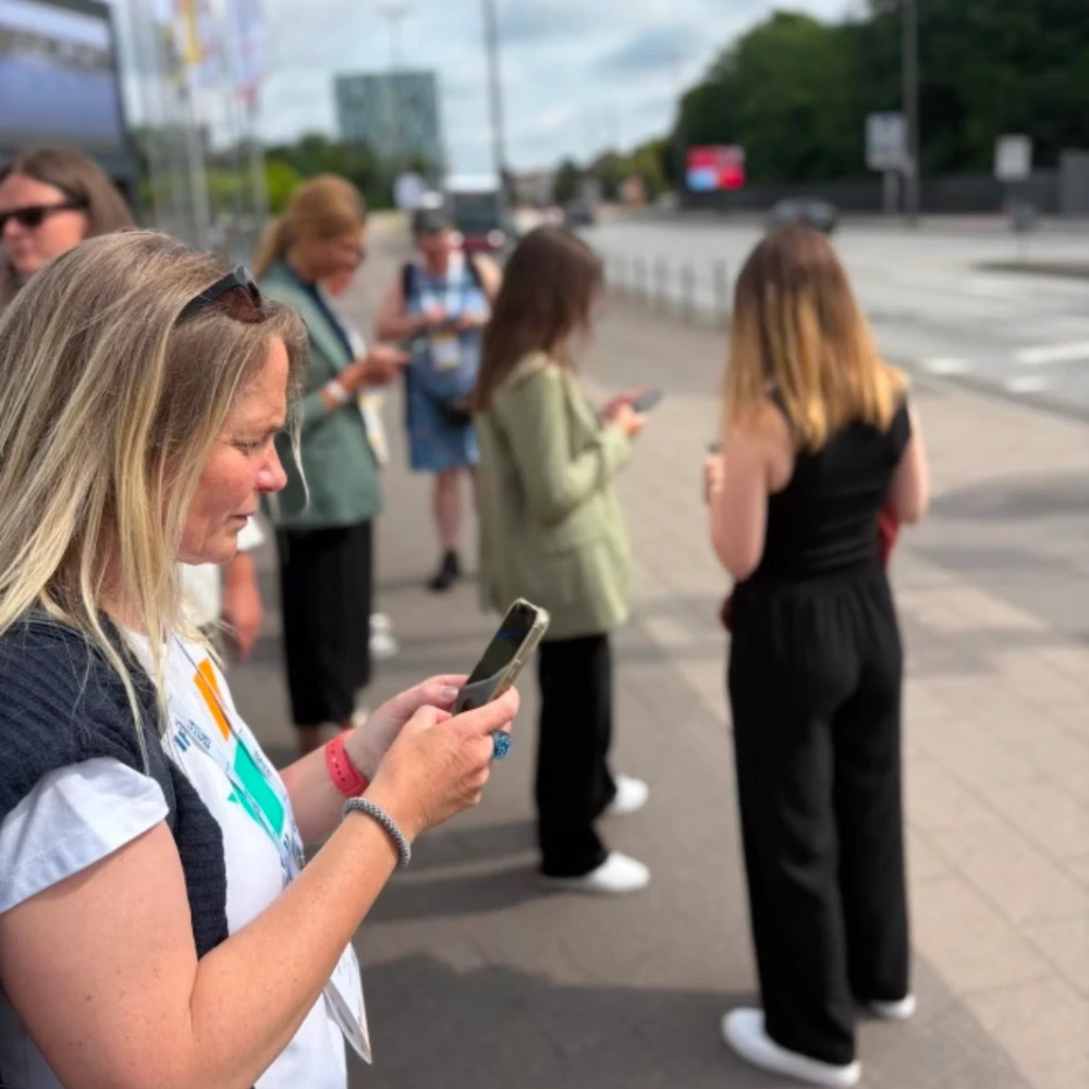
Women in Mobility Berlin wanted to gather in-depth, in-person feedback on the inclusivity of urban mobility in Hamburg, Germany. Their solution was to combine a "walkshop" with a Maptionnaire digital survey, which immediately produced results on respondent diversity and perceptions of mobility at specific Hamburg locations.
.webp)
In Finland, the Helsinki Regional Transportation Authority (HSL) aimed to boost public transit ridership and cut carbon emissions. Their challenge: comprehensively understanding people's routes, destinations, and other mobility needs across a huge service. Their solution: HSL used a digital, map-based questionnaire to engage over 30,000 residents. The digital data was easy to compile, visualize, shared back with the community, and utilize in transit development.

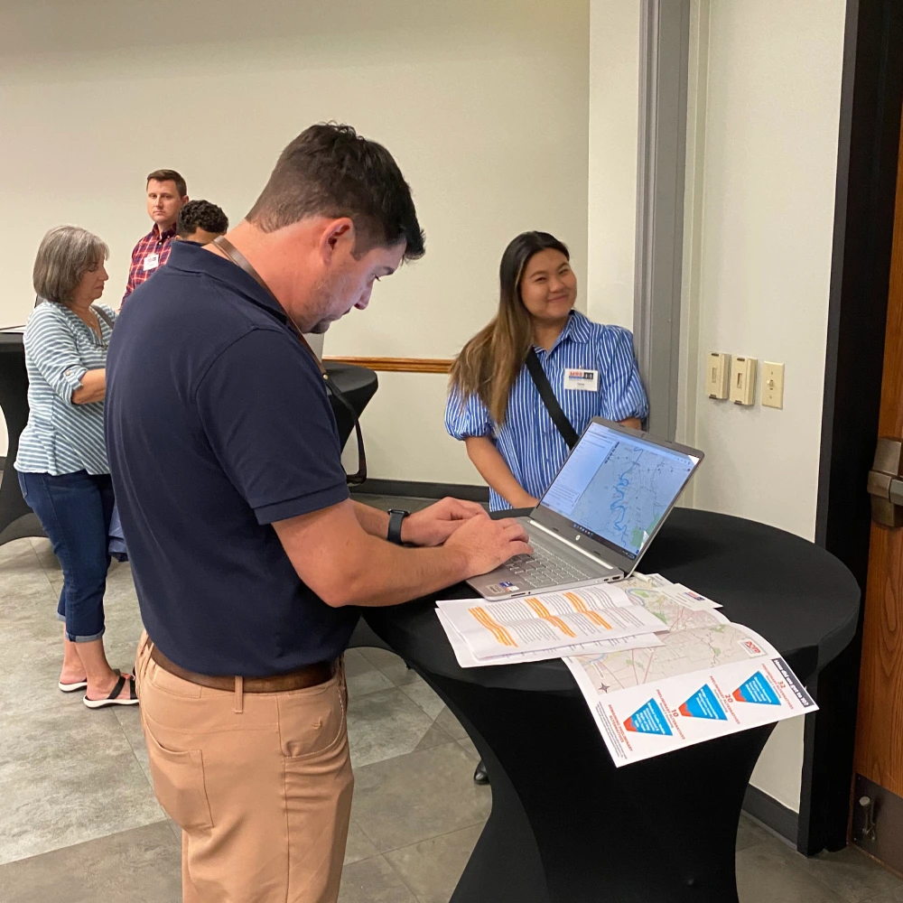
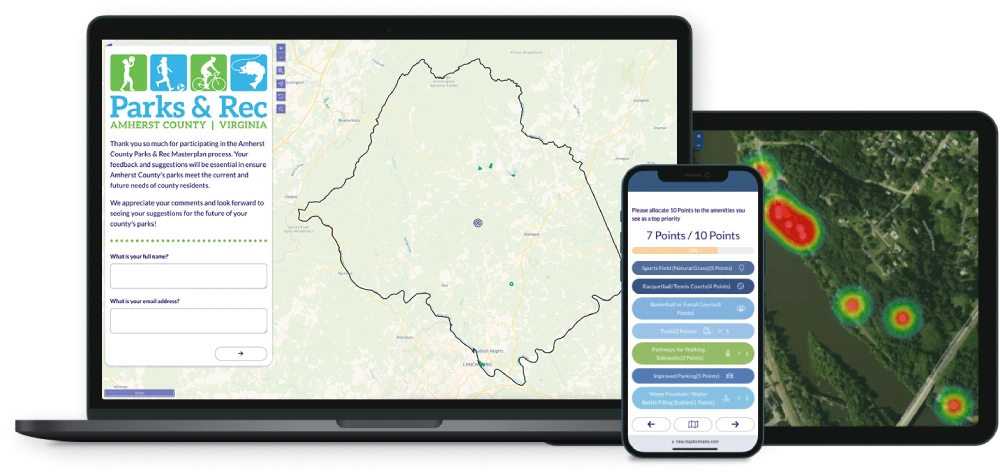
Community planners at Hill Studio empowered locals to map their ideas for the Amherst County Parks and Recreation Master Plan in Virginia, USA. The goal was to understand what community members valued about parks and their potential. Their solution was an engaging hybrid approach: pop-up booths with a physical mapping game, a parallel online mapping game, and focus groups. The results? Valuable and sometimes unexpected ideas.


Mintier Harnish, a planning firm in California, USA, needed community mapping input for eight community plans across Trinity County. The project did not have resources to host workshops all across a large, rural geographic area. Thankfully, Maptionnaire's digital map-based questionnaire allowed them to collect robust, mappable data. This information became the foundation for defining geographic boundaries and identifying local resources for each plan.
Planners at UN-Habitat upgraded their community mapping methods to understand vulnerable neighborhoods, in Al-Mafraq, Jordan. At first frustrated with inefficient manual mapping techniques, they adopted the Maptionnaire platform to develop map-based questionnaires for facilitated community workshops. This made data collection more efficient and accessible, even for participants with limited literacy.


.png)

.webp)


.webp)

-min.webp)
.webp)
.webp)


.webp)


.webp)


.webp)


.webp)
.webp)
.webp)


.webp)


