

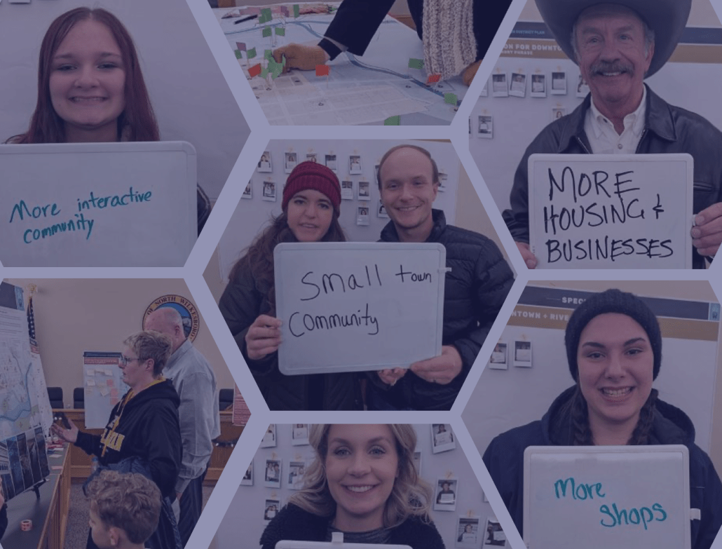
With community engagement tools, urban planners and GIS specialists can gather soft data and insights from residents for a particular urban or regional development project. This soft data complements hard data gathered from other resources.
While some projects stop there, others push the collaboration between residents and cities even further by presenting the results and project outcomes. It takes an effort to be transparent and overcome silos within governmental departments, but the results are worth it.
The faculty and students of the Applied Geo-Information Science Department at HAS University of Applied Sciences in the Netherlands have used Maptionnaire for gathering valuable soft data from community engagement.
With a good Maptionnaire project, you can not only collect the soft data but also present the data back to the community. Our students are surely capable of doing that, but for a lot of governmental organizations this is difficult.
Erik Dietvorst, Senior Lecturer of Applied Geo-Information Science at HAS
On a positive note, Erik and his team ensure that the next generation of researchers and policymakers think differently about public participation. They teach students in the Smart Regions course how to run community engagement using Maptionnaire.
Then, students practice gathering soft data for regional and urban development projects, combining it with hard data, and applying these results to solving environmental and societal challenges.
Introducing Community Engagement to the Smart Regions Course
HAS University and its Applied GIS Department are on a mission to equip students with diverse skills to tackle real-life challenges. And when it comes to creating and maintaining regions, with their cultural, environmental, and social diversity, GIS specialists need to be in conversation with residents of these areas.
Recognizing this need, the faculty introduced Maptionnaire in their Smart Regions course. Maptionnaire is a community engagement platform that captures soft data from residents through map-based surveys. It then transforms it into applicable, comprehensible geo-located data.
And the best part of this course: for their projects, students work with local partner organizations, being able to impact regional development already at the start of their careers! Research into practice at its best. And later, one cohort of students came to Maptionnaire to present their projects and discuss with the team their experiences of using the tool for gathering soft data.
Soft Data vs Hard Data in Regional and Urban Development
An area can’t be comprehensively described, understood, and developed only with hard data reflecting its biodiversity, air quality, or population density. Every location is also a container for human experiences, local knowledge, practices, and meanings attached to it. In other words, what do residents think and how do they use a certain space?
This wide range of human attachments to a place is often invisible, and such qualitative soft data is notoriously hard to grasp and assess. But should it prevent us from using this soft data for regional development? Absolutely not, especially when a community engagement platform like Maptionnaire helps you combine soft data sourced from residents with quantitative GIS data.
The power of Maptionnaire is in getting the soft data from the residents.
Erik Dietvorst, Senior Lecturer of Applied Geo-Information Science at HAS
With Maptionnaire, professionals can get actionable results from community engagement processes and accommodate this varied data into regional and urban development projects. Moreover, it opens up new avenues for research and interdisciplinary collaboration — something that HAS faculty and students are striving for.
Maptionnaire in the Smart Regions Course
“Our students use a lot of data, but I’d say it’s mainly hard data,” explains Erik, who’s a coordinator of the Smart Regions course. “But within this course, we also teach them how to use soft data of residents’ experiences. That’s where Maptionnaire is especially useful.”
Erik brings in an example. A sensor says that the air quality is acceptable, but the survey of residents’ opinions paints a completely different picture — they experience air pollution and difficulty breathing. Which data should be used to define future developments? Most certainly, it’s a critical combination of both sensor data and soft data.
Students of Smart Regions start with a theoretical introduction to community engagement, which is followed by two modules about Maptionnaire. Participants get to master the tool itself and the secret of formulating good survey questions. Asking questions is not as simple as it seems, and lean survey design is crucial for obtaining the right data and getting desirable response rates.
Students are “self-sufficient” when it comes to mastering a new tool like Maptionnaire, comments Susan van Dijk, Senior lecturer of Applied Geo-Information Science at HAS and instructor for the course. What they also learn is how to transfer raw soft data, sensor data, or data about infrastructure and other facilities into other tools for analysis and data visualization. This workflow replicates the usual way of processing this data and presenting the research results.
For the final assignments, students worked on their own projects related to traffic safety, awareness of physical risks, effects of greenery on exercise motivation, and air quality. The research was supported by partner organizations, who later used the data presented in heatmaps, 3D visualizations, and storymaps in their development processes.
What do residents think about sustainable energy?
One of the projects analyzed how residents in a neighborhood feel about the energy transition. Knowing residents’ ideas would help municipalities co-design and implement sustainable energy practices.
Students collected soft data from residents on their current use of green energy (for example, solar panels) and on their will to commit to the upcoming energy transition process. The project also found out what are the key concerns around sustainable energy, which are required to know to design policies and education campaigns.
And although the timeframe didn’t allow to gather a highly representative sample, the study gained visibility. This project kickstarted a conversion between residents and the municipality about sustainable energy.
Here is a link to the Sustainable Neighborhood project.
How safe is biking in Eindhoven?
Another student project used Maptionnaire for transportation and mobility analysis. The project made for Eindhoven’s City Lab inquired how safe the cycling infrastructure is in Eindhoven. While the ultimate goal is to improve the infrastructure, the municipality decided to rely not only on quantitative but also on qualitative data provided by local cyclists themselves.
In this questionnaire, cyclists answered questions about their experiences and could pinpoint on a map dangerous and uncomfortable places. Several issues came up, for example, school areas didn’t feel protected from car traffic, bike parking around the railway station was not well-organized or secure enough, and some roads were dangerous due to speeding cars.
The results of this survey were not statistically significant to bring them to the policy level. But the survey has been noticed by the National Cyclists' Association and may be carried out in several places in the Netherlands.
Here is a link to this project on cycling safety in Eindhoven.
Maptionnaire as an Interdisciplinary Tool
What’s more, a group of students researched whether two departments at HAS University — Applied GIS and Urban Planning — could work together with Maptionnaire. Urban planning students have a lot of theoretical knowledge, while students of GIS specialize in geoinformation and geoscience.
And working together on a project with Maptionnaire creates synergy. Urban planners prepare the survey and GIS students can analyze and visualize geolocated data. But the collaboration doesn’t stop here: where a GIS specialist sees just a heatmap, an urban planner can spot a trend. Together, they can explain this trend and decide on the next steps.
Altogether, students have mastered how to gather, validate, and correlate data, link different layers, apply their knowledge in statistics, and visualize data. But most importantly, they have learned how to think about soft data and how to find patterns and validate theories. And this interdisciplinary combination of soft and hard data skills will advance their careers.
Maptionnaire thanks Erik Dietvorst (Senior lecturer of Applied Geo-Information Science, HAS), Huub Bruens (Senior lecturer of Applied Geo-information Science, HAS), Susan van Dijk (Senior lecturer of Applied Geo-Information Science, HAS), Max de Visser (Junior lecturer of Applied Geo-Information Science, HAS) who have introduced Maptionnaire to HAS students and also helped to prepare this story. And greetings to the students!


.jpeg)
.webp)

.webp)


.webp)
.png)


